I. Appendix - Annotated Maps of Chongyang County
The following maps are reproduced from the Chongyang County Gazetteer 崇陽縣志 produced in 1866.
Still to be added: Maps from the Hubei tong zhi 湖北通志 (Jiaqing, edited by the gazetteerophile Zhang Xuecheng 章學誠 (1738-1801)), from Hubei tongzhi (1921), and perhaps from Zhongguo lishi ditu ji 中國歷史地圖集 (1982). (There are apparently Chongyang gazetteers from Kangxi and Qianlong, as well.)
Ideally, the last step will be to produce a .KMZ file noting all of these locations for comparative purposes. Obviously, the hand-drawn Qing maps are not to scale, and the distances between places mentioned in the documents are approximate, so it would be empirically interesting to see exactly how far these places were/are from each other.
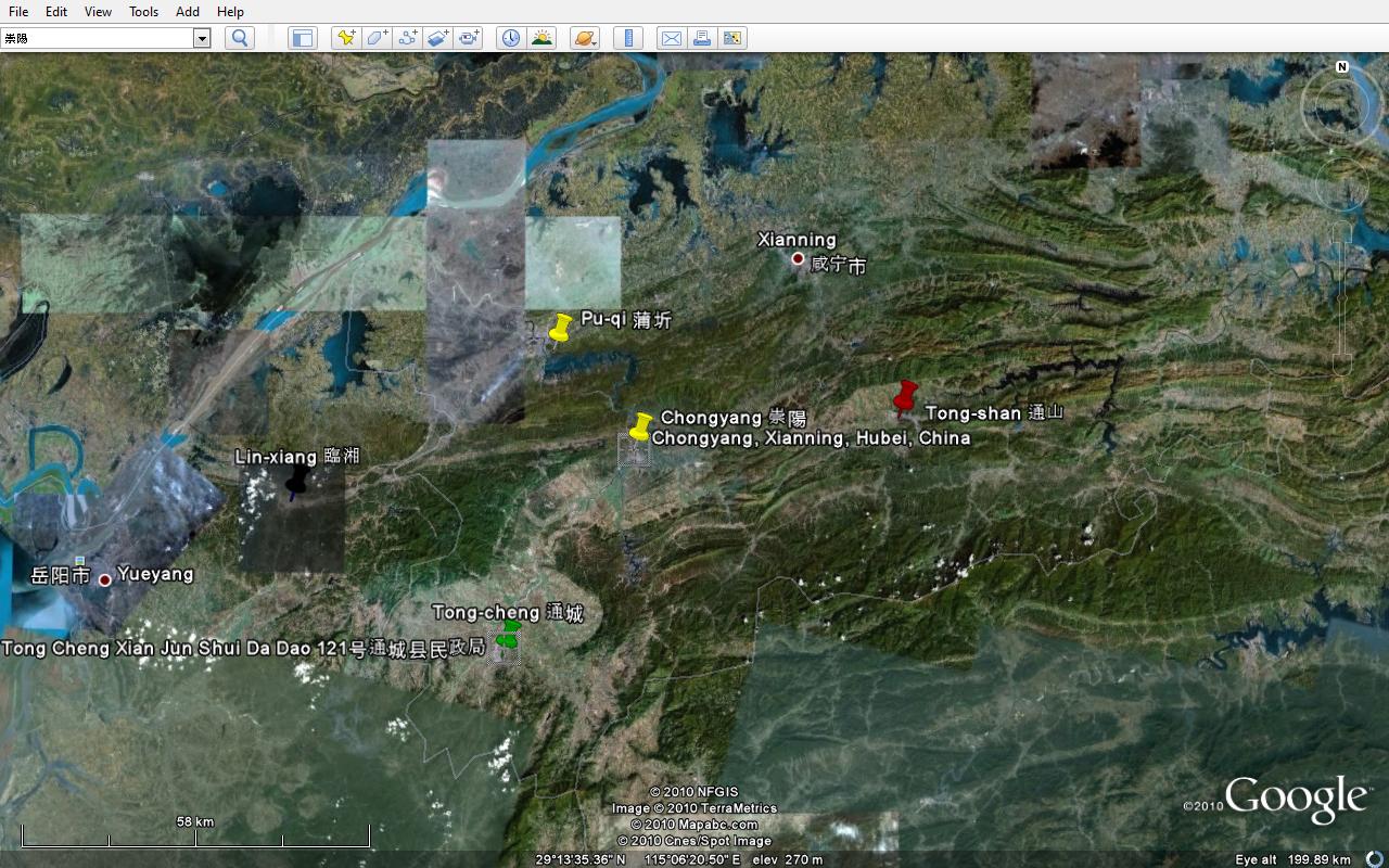
Before looking at these maps, it is useful to consider a more recent representation of the region. The following is another version from Google Earth:
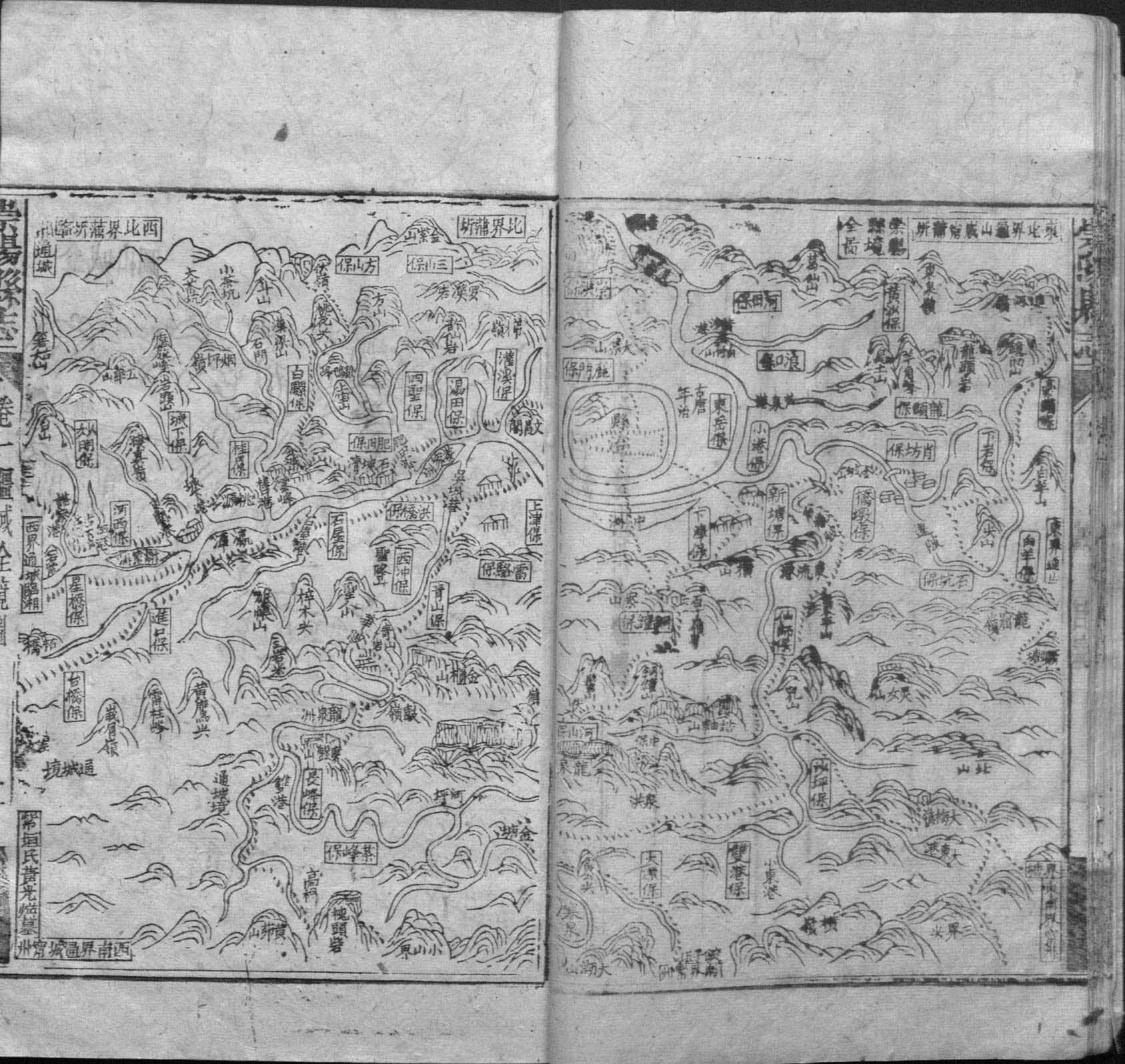
Maps from the Chongyang County Gazetteer (1866)
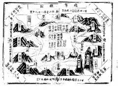
Map of the whole area of Chongyang County
崇陽縣境全圖 is reproduced from juan 1.
An annotated .PDF is avaliable here. (Mouse over yellow circles for pop-up text or click to edit in Adobe Acrobat.)
Notes
Note the orientation of the map: North is up, south is down, east is right, and west is left. Each corner and side is labeled to indicate what lies over the county border in that direction. Clockwise:
- North: Pu-qi 蒲圻
- Northeast: Tong-shan 通山, Xian-ning 咸寧, Pu-qi
- East: Tong-shan
- Southeast: Ning-zhou 寧州
- South: Ning-zhou
- Southwest: Tong-cheng 通城 and Ning-zhou
- West: Tong-cheng and Lin-xiang 臨湘
- Northwest: Pu-qi, Lin-xiang, and Tong-cheng
Landmarks
- Zhong Renjie's home of Qiaodun bao 橋墩堡 is located on the right-hand leaf, slightly above center, south of and enclosed on two sides by a fork in the river.
- The county seat is indicated with the word 縣治 xian-zhi inside a roughly circular enclosure indicating a wall. It is located on the right-hand leaf, west of Qiaodun.
- Just to the east of the county seat is the old Tang-period capital, 古唐年治 gu tang-nian zhi. (Where is this located, according to 中國歷史地圖集?)
- Just south of the county seat, across a river, is something crescent-shaped labeled "中X". (The X has a water radical.) What could this be?
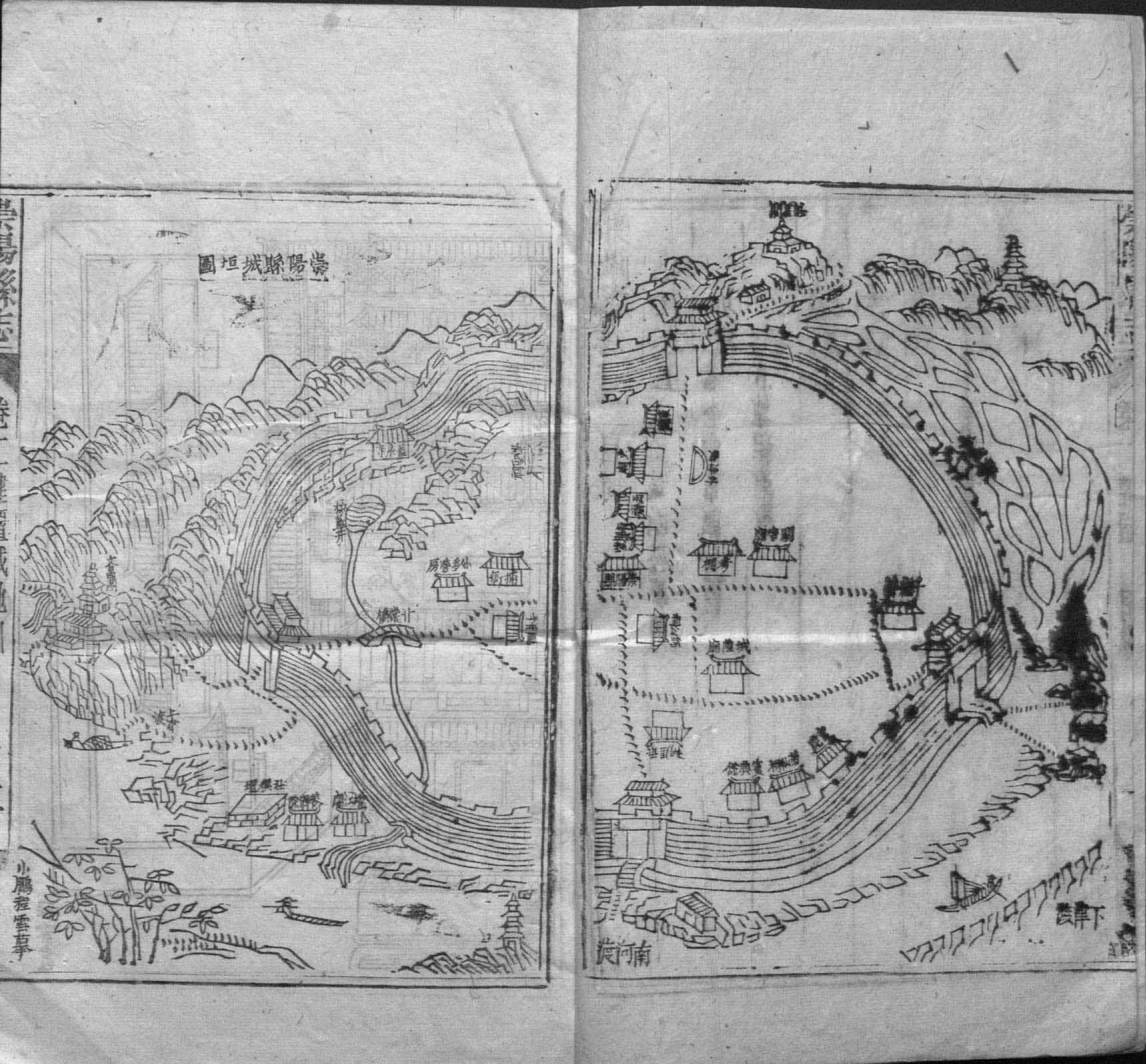
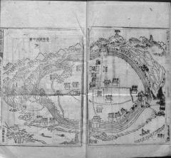
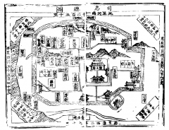
Map of the county seat of Chongyang
崇陽縣城垣圖 is reproduced from juan 2.
This detail of the Chongyang county seat is also oriented with north at the top. Note the kinds of buildings and features labeled on this map: Temples, some official buildings, wells, and a bridge. Although it is interesting to note the sheer number of temples in Chongyang, this does not help us locate the jail or the granary raided by Zhong Renjie. One central building, however, is clearly labeled Chongyang xian zhi.
Chongyang's seat seems very defensible. It borders mountains to the north and a river to the south. Where might Zhong Renjie's crowd have camped out? Made its stand? Broken through the wall?
This map is a challenge to read, not only because the ink has smudged, but because labels on buildings are written at various angles, depending on the orientation of the buildings themselves.
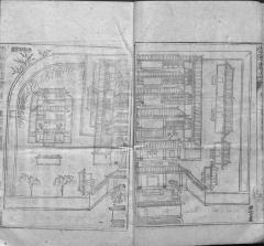
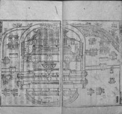
Map of the Chongyang county magistrate's yamen
崇陽縣署圖 is reproduced from juan 2.
There is little to be learned directly from this map, though it is interesting to see the environment in which county officials might have lived and worked.
Did Shi Changzhi live here? Or was his residence off-site?
Note the name in the bottom-right corner, 程雲 Cheng Yun. His name appears on all of the gazetteer's maps. Was this the person who drew the map? Who could he have been? Was he a county official himself? A local licentiate?
Map of the Chongyang county school
崇陽縣學官圖 is reproduced from juan 3. 學官 may be an error or simplification for 學館 xue-guan "school."
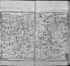
Maps from 湖廣圖經志書 (明嘉靖)
The following maps have been copied from a Jiajing (1522-1566)-era gazetteer of Hubei. The work was compiled by Xue Gang 薛綱 (jinshi 1464) and further edited by Wu Tingju 吳廷舉 (jinshi 1487). There are two volumes of the book: Volume I & Volume II.
A photoreproduction of the gazetteer, from which these maps were in turn reproduced here, can be found in Riben cang Zhongguo hanjian difang zhi cong kan vol. 1, which is available at HYL.
Map of Provincial Administration Commission
Map of Xianning County
Map of Chongyang County
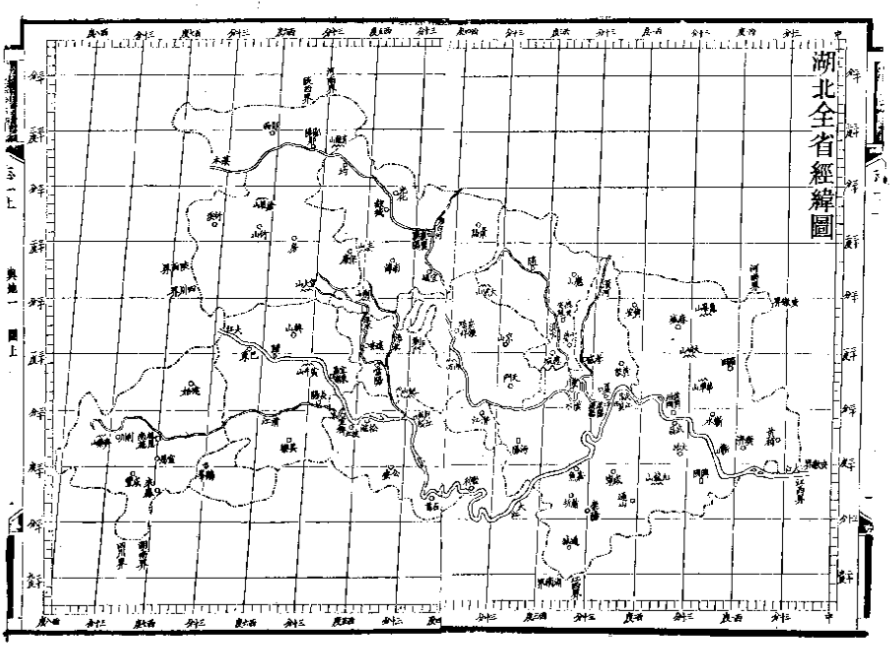
Maps from 湖北通志 (1921)
Map of Hubei Province
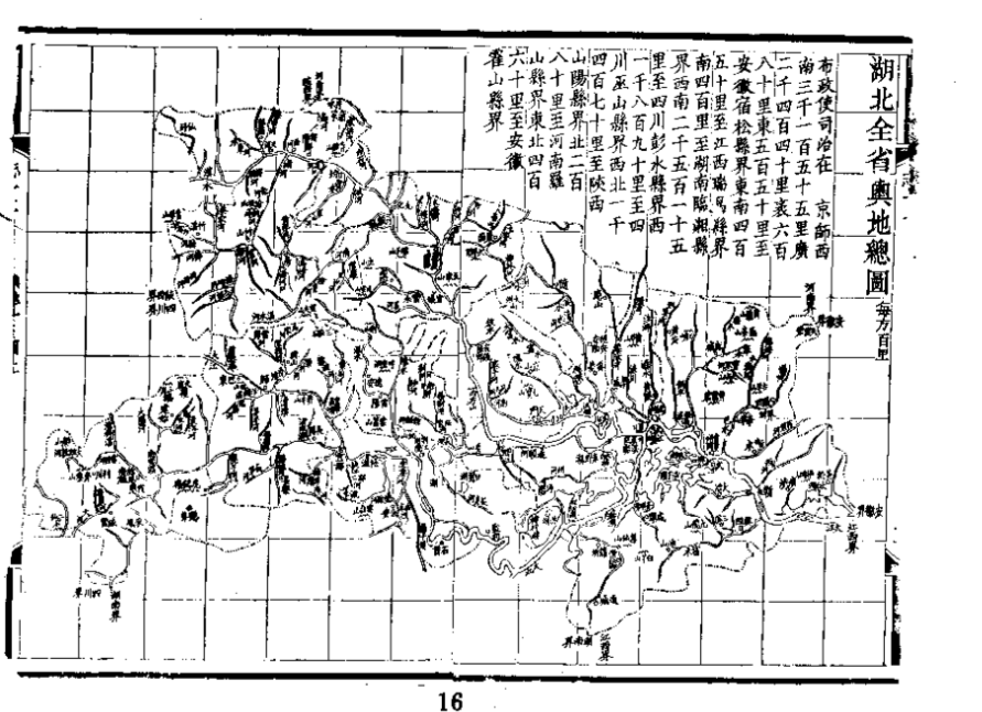
According to the map, the distance between Hubei Province and the capital is 3155 li.
Map of Xianning County
Map of Chongyang County
Bibliography
Elman, Benjamin. "Geographical research in the Ming-Ch'ing period" in Monumenta Serica v. 35 (1981-1983), pp. 1-18.
This page has paths:
This page references:
- Appendix - Annotated Maps of Chongyang County
- Appendix - Annotated Maps of Chongyang County
- Appendix - Annotated Maps of Chongyang County
- Appendix - Annotated Maps of Chongyang County
- Appendix - Annotated Maps of Chongyang County
- Appendix - Annotated Maps of Chongyang County
- Appendix - Annotated Maps of Chongyang County
- Appendix - Annotated Maps of Chongyang County
- Appendix - Annotated Maps of Chongyang County
- Appendix - Annotated Maps of Chongyang County