Convergence
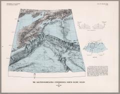
If you were skeptical about the notion that Aleutian Islands and Kamchatka were really all that intimately connected, this is the map for you. What the oceans obscure is laid bare: the geographical sweet-spot where the Kuril Trench meets the Aleutian Island chain.
If you look closely at the Aleutian chain, you will see the Near Islands and Commander Islands (with Bering Island closest to Kamchatka) rising up out of the water.