The General
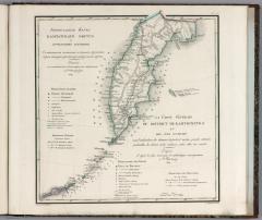
The General Map of Kamchatka and the Kuril Islands was that mapping. Lt. Colonel Vasilii Petrovich Piadyshev oversaw the first truly comprehensive and "accurate" atlas of the Russian Empire. This immense cartographic project was conducted by the General Staff in the 1820s, and it would serve as a key source for maps of Russia produced elsewhere in Europe in subsequent decades.
Noteworthy Features
- Mindful of the linguistic profile of educated Russians and of the scientific community abroad, titles, legend, and placenames are offered in both Russian and French.
- Two post routes lead northward from Petropavlovsk. The main (inland) route follows the Kamchatka River past Verkhne Kamtchatsk (with a local spur leading east to Nijne Kamtchatsk), while the local route heads due west and follows the coast up the peninsula.
- Kamchatka has been extracted from its surroundings: mainland Siberia is nowhere to be seen.