Navigator's Delight
Formal Title (located top center)
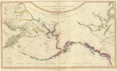
Chart of the N.W. coast of America and the N.E. coast of Asia, explored in the years 1778 and 1779. Prepared by Lieut. Henry Roberts, under the immediate inspection of Capt. Cook.
Advertisement (located just below the formal title at the top center of the map):
The Interesting Discoveries made by British and American Ships, since the first Publication of this Chart in 1784, Together with the Hydrographical Materials, lately procured from St. Petersburg and other places, have enabled Mr. De La Rochette to lay down the Numerous Improvements which appear in the Present Edition. [W. Faden, Charring Cross, January 1, 1808]
Publication note (located bottom right)
Engraved by W. Palmer, no. 128 Chancery Land.
Publication note (located bottom center)
London: published by Wm. Faden, geographer to the King, Charing-Cross, July 24, 1784. 2d. edition, published January 1st, 1794.
The map is chock-full of stories and observation and references - to other maps and to the many voyages made in the North Pacific. It is very much worth your while to zoom and pan in Rumsey's Luna Browser. Note the leap in geographic knowledge of the North American coast: Alaska and the Aleutian Islands are at long last recognizable.