swamps
Ah, swamps. Everyone's favorite topic. The cards make note of their presence, and often specify "a significant quantity," but otherwise we are left to imagine what they looked and smelled like, and whether they were seen as resources or obstacles. (And we ought to fess up: we have translated болота (bolota) as "swamp" but it can also be translated as "marsh," which is considerably less dramatic-sounding.)
Starter Question:
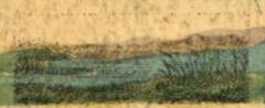
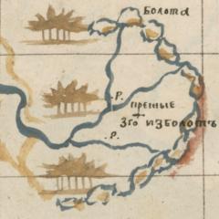
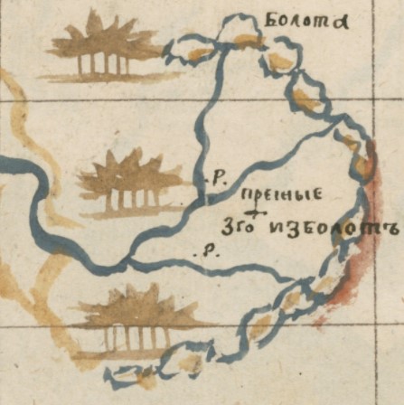
Swamps and marshes were common elements of the imperial landscape. While most maps you encounter do not bother to show them, they do play a prominent role on the maps of Siberia made by Semyon Remezov in 1696. Remezov produced 150 river maps (plus a great many others) for something he called the Chorographic Sketchbook. (Think of it as a manuscript atlas of Siberia.) The maps tell extraordinary stories about Siberia and contain some 9,000 pieces of information about what was where at the turn of the 18th century. On Remezov's maps, swamps/marshes look like this:There are 295 swamps - or, to be more accurate, swampy/marshy areas - in the Sketchbook. Ready for your challenge? Try finding the swamps shown on the map below, which shows a segment of the Vagay River. And perhaps, if you can find them, you might try your hand at identifying some of the other geographic features of the map.
(Tip: Toggle off the side panel to see the map a bit better.)
Note: If you are interested in swamps, you might want to compare them with salt lakes or wade into the Putrid Sea.