Habitats
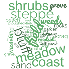
One of the most important characteristics of the flora data is that it documents the habitat(s) in which each species of plant grew. The language of the primary source gives us a clear sense of the elements that composed the area around Odessa in the 1890s - of the meadows, sand, and coastline. There were marshes and rocky areas, gardens and riverbanks. We can almost smell the salt.
But here's the catch.
We don't know which meadows Shesterikov studied. We don't know which "sandy areas" he explored. We don't even know where the sandy areas were in the 1890s. When Shesterikov tells us he saw German madwort (Asperugo procumbens) growing in abundance along a roadside near the village of Großliebental we can map the village but go no further. It's the equivalent of telling someone to go find the maple trees growing on "the street" in the city of Cambridge, Massachusetts.
Here's what we can do.
First, let's look at a rough breakdown of the full set of habitats listed in the Flora Odessa and count the occurrences of each. Click on an item in the legend below to activate the category. Click again to clear the selection. Hover over any colored area in the treemap to reveal the number of occurrences.
Second, we can put the data on the map