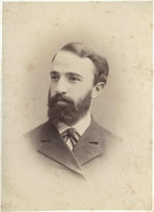
Sample of Shesterikov's handiwork
1 2024-03-21T01:31:58-04:00 Kelly O'Neill dc20b45f1d74122ba0d654d19961d826c5a557f5 9 5 plain 2024-03-21T11:51:55-04:00 Kelly O'Neill dc20b45f1d74122ba0d654d19961d826c5a557f5This page has paths:
- 1 2024-03-07T15:58:56-05:00 Kelly O'Neill dc20b45f1d74122ba0d654d19961d826c5a557f5 Odessa in Bloom Kelly O'Neill 54 image_header 2024-03-23T16:27:38-04:00 Kelly O'Neill dc20b45f1d74122ba0d654d19961d826c5a557f5
This page is referenced by:
-
1
2024-03-07T15:58:56-05:00
Odessa in Bloom
54
image_header
2024-03-23T16:27:38-04:00
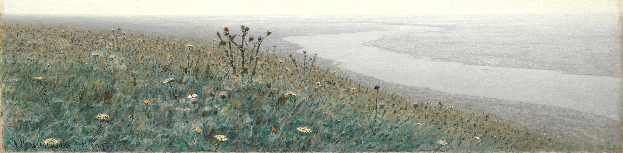
The Big Picture
The cost of Russia’s war against Ukraine is high, whether calculated in terms of the loss of human life, cultural heritage, or landscape. In the face of all that is being destroyed, this project will help preserve the history of the natural world of Ukraine, starting with some of the most fragile elements of the ecosystem: plants.
Perhaps it is a small thing to know where the sunflowers grew around Odessa in the 1890s, but it is a powerful thing to be able to talk substantively about changes in biodiversity and the evolution of the built environment over time.
We have another motive for working with botanical registers as well. Tsarist bureaucrats described their domain - in this case southern Ukraine - in terms of provinces and districts, but naturalists and farmers saw hillsides and coastal cliffs, flooded meadows and suburban kitchen gardens. Non-state actors used rich, highly localized spatial vocabularies to describe the world around them. It isn’t easy to put those places “on the map.”
We like a good challenge. And it is worth it. Attempting to "see" historical space from the perspectives of those who inhabited it is an essential task for anyone trying to understand the past.Botanical Data
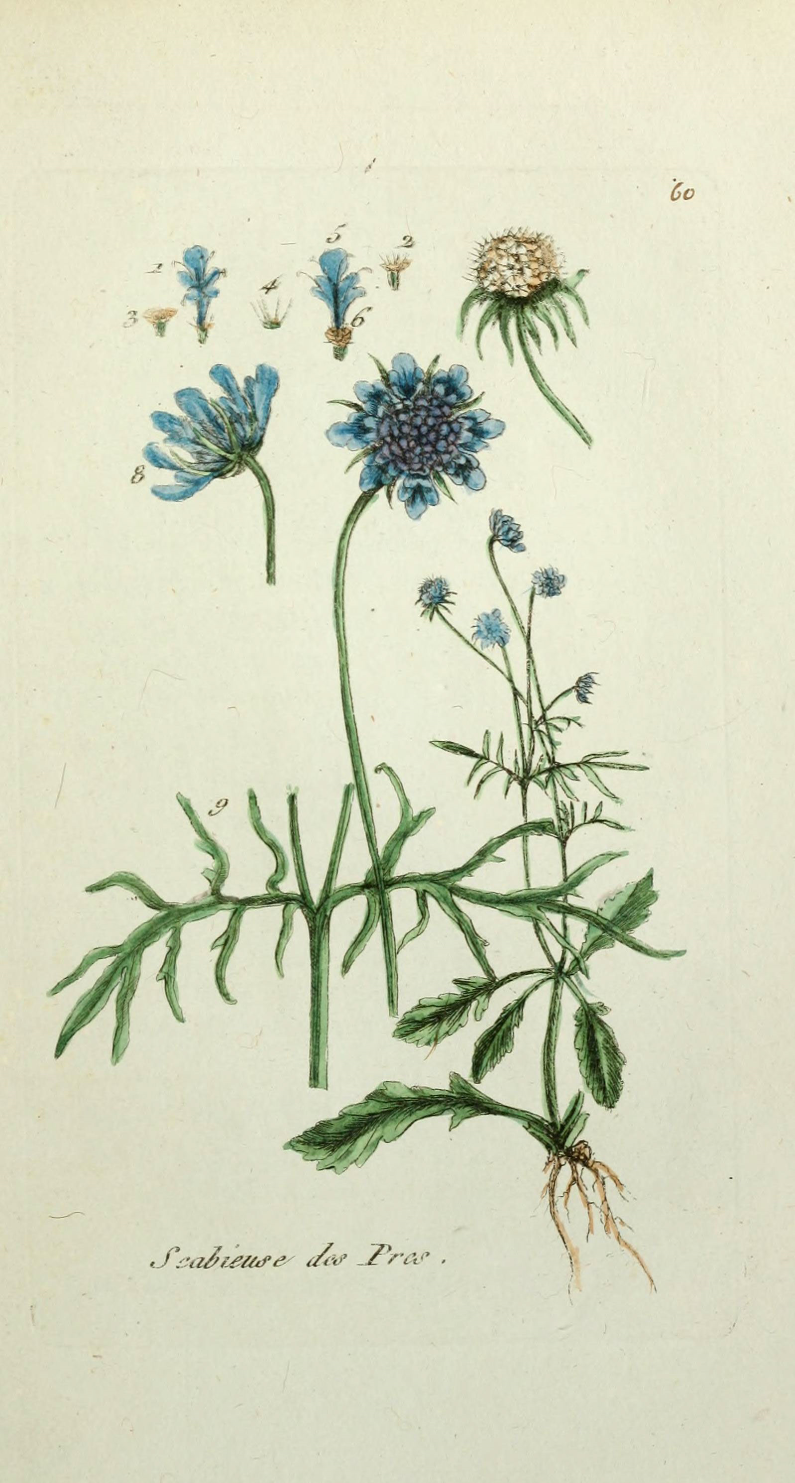
In the 19th century, botanists combed the land, intent on documenting every plant they could find, from cowbane to chokecherry. We are studying the lists they compiled and building a database that enables us to analyze distribution and prevalence. We are doing this because 1) the history of vegetation and cultivation is important in its own right, 2) plants serve as proxies for other silent actors in the environment, such as soil, insects, and wildlife, and 3) mapping plants is absurdly difficult and therefore fun.
We started with a flora (a list of plant observations) published by Petro Stepanovich Shesterikov in 1894. Shesterikov (1859-1929) was a botanist and librarian of Novorossiia University, a member of the Imperial Russian Geographical Society, the Kiev Society of Naturalists, and the Novorossiia Society of Naturalists. He conducted fieldwork 1890-1891 between the banks of the Dnestr (Dniester) and Tylihul' (Tiligul’) rivers, describing his work as an effort to reveal the “geobotanical character” of the region.
Shesterikov's list has 950 entries, some of which merely state that previous botanists were wrong to claim [plant X] grew in the Odesa region. Once we pulled those out and eliminated observations of plants growing in other regions, we were left with a list of 815 species. Shesterikov observed many species in multiple locations, giving a total of 2,834 observations.
In fact, before we go any further, here is the data profile:- 815 plant species
- 77 plant families
- 2,834 observations
- 45 observation sites
- 79 habitats
The data describes flowering plants, edible plants, plants that provide ground cover, shade, and protection against flooding. They run the spectrum from humble pond weeds and leafy rock dwellers to roses gracing the banks of estuaries. You will find milkwort, eel grass, St. John's wort, dogwood, and honeysuckle. Shesterikov named plant species in Latin. We have added their common English names in case you, like us, decide that keeping track of family, species, location, habitat, prevalence, and growth type is enough of a challenge.
The project pages (see the links below) dive into each of those variables. Together they open a window on the natural world at the end of the 19th century. But remember, as much as there is to "see" here, Odessa in Bloom is built around a single primary source. It draws on only one of the dozens of flora that document botanical biodiversity in southern Ukraine and the Black Sea region. It is nothing more than a (metaphorical) seed. An early bloom.What if you have no interest in plants?
We have something for you, too. See, the thing is that plant names are highly entertaining. Don't believe us?
This project was made possible thanks to funding from the Harvard Data Science Initiative and support from the Davis Center for Russian and Eurasian Studies.
This page references:
- 1 2023-08-10T09:58:52-04:00 Eruca Sativa record 1 plain 2023-08-10T09:58:52-04:00