The Imperiia ProjectMain MenuResearch Dashboardsmaps, visualizations, and moreVeles: The Data CatalogOngoing ProjectsThe MapMaker PodcastEvery story starts somewhere.Teach with MapsGalleriesKelly O'Neilldc20b45f1d74122ba0d654d19961d826c5a557f5The Imperiia Project // Davis Center for Russian and Eurasian Studies, Harvard University
verst
12019-07-23T20:50:48-04:00Kelly O'Neilldc20b45f1d74122ba0d654d19961d826c5a557f591glossary termplain2019-07-23T20:50:49-04:00Kelly O'Neilldc20b45f1d74122ba0d654d19961d826c5a557f5type: linear measure equivalent in sazhens: 500 equivalent in miles: 0.663 equivalent in kilometers: 1.0668
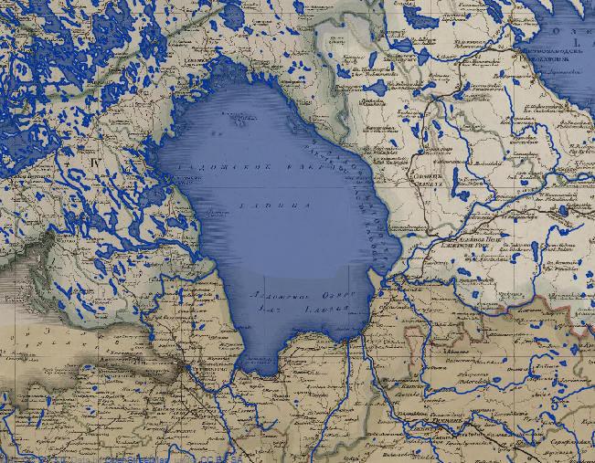
12019-07-11T04:03:02-04:00Lake Ladoga1gazetteer entryplain2019-07-24T02:58:12-04:00Short Universal Geography Dimensions: 175 versts long, 105 versts wide Primary inflows: the Volkhov, Svir, Sias, Pashu, Oiat, and others Primary outflow: the Neva What to remember: "Lake Ladoga is the greatest lake in Europe."
New and Complete Geographical Lexicon Location: between the Gulf of Finland and Lake Onega Dimensions: 175 versts long and 105 versts wide Primary outflow: the Neva What to remember: Lake Ladoga was one of the largest and fish-rich rivers in Europe. Because of the frequent storms and prevalence and unpredictability of shoals, flat-bottomed boats often capsized and were lost. Tsar Peter I therefore decided that it was necessary to build a canal (104 versts by 10 sazhens, with a depth of one and a half sazhens) along the southern shore of the lake, from Shlisel'berg to Novaia Ladoga on the Volkhov River. Work began in 1718 and was complete in 1738.