This path was created by Sara Bobok.
Odessa - Image Close Reading
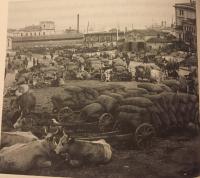
This image reflects the organization and complexity of Odessa as a port city. In the far horizon of the photograph, one can see ships and the sails of ships along the moles. The harbor opened up the Russian empire to other countries with which it could trade across the Black Sea. From the Mediterranean, it imported luxury items, oil, and wine, and exported “honey, wax, amber, furs, skins, slaves, … wheat” from the North (Herlihy 2).
However, Odessa’s potential did not end there. In front of the ships, there are three carts in a shedded area, presumably train cars. Odessa’s railway allowed it to not only connect internationally by sea, but also by land. The railway introduced new migrations of settlers as well as trade from the hinterlands (Sifneos 26).
In the foreground of the image, oxen rest in grass areas off of the main roads, identified by their lighter color. This indicates that the port workers had a system and order for their daily tasks, which included keeping clear pathways of travel to avoid traffic along the harbor.
The resting oxen are surrounded by many sacks of presumably grain, one of Russia’s greatest exports (Herlihy 65). Lastly, one can see the outline of men along the roads. They can be identified by their hats and pants. The absence of women reveals the gender roles in specific occupations during this time period. Trading and management were left primarily to male workers.
Citation for image: “Oxen and wagons filled with sacks of wheat in the port of Odessa, from a nineteenth-century photograph. Author’s collection.”