The Imperiia Project: a spatial history of the Russian EmpireMain MenuProjectsDashboardsData CatalogMapStoriesGalleriesGamesWho said history was boring?Teach Our ContentCiting the ProjectKelly O'Neilldc20b45f1d74122ba0d654d19961d826c5a557f5The Imperiia Project // Davis Center for Russian and Eurasian Studies, Harvard University
forests in Plotsk
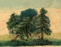
12020-08-26T23:29:33-04:00Kelly O'Neilldc20b45f1d74122ba0d654d19961d826c5a557f591detail of geographic playing cardplain2020-08-26T23:29:33-04:00Kelly O'Neilldc20b45f1d74122ba0d654d19961d826c5a557f5
This page is referenced by:
12020-08-17T01:43:43-04:00forests24playing card taggoogle_maps2022-05-18T03:39:25-04:00What does the map above tell you?
The cards speak not of forests, but of "bountiful forests."
Starter Question:
Chukotka/Kamchatka and the lands of the Black Sea Cossack Host are some 4,000 miles apart. But they share two common geographical features: forests (of course) and... can you figure out the other?
12020-08-17T01:34:17-04:00lakes12playing card taggoogle_maps2020-09-14T23:26:16-04:00What does the map above tell you?
Lakes were a prominent - almost ubiquitous - element of the empire's geography. Along with rivers, they are among the few features included on the small map insets on the cards. We only attached the "lakes" tag in cases where they were specifically mentioned on the cards. (Salt lakes are treated separately.)
There is only so much you can learn about Russia's lakes from a set of playing cards. That said, they do include nuggets of information here and there. We learn, for example, that Novgorod Province has 3,220 lakes, and Lifliand has 1,000.