Cold Snap
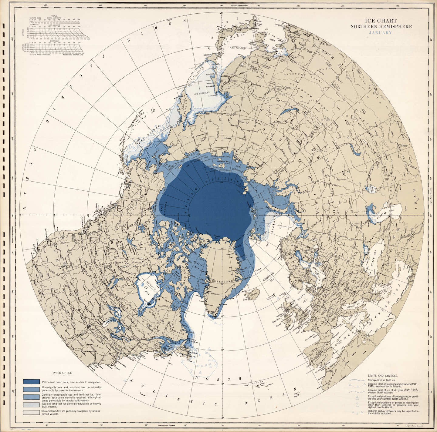
1 2026-02-19T15:26:04-05:00 Anastasiia Pereverten 1dee3aa5075817eb04077dbae88a1030d7d4ebb4 9 1 As the end of the month approaches, we are leaning into winter with a selection from the David Rumsey Historical Map Collection. This ice chart of the Northern Hemisphere takes us back to January 1946. Produced by the U.S. Navy’s Hydrographic Office, it reflects growing interest in polar regions, shipping routes, and risks to navigation. Look carefully and you will see that the chart distinguishes permanent polar packs from areas of sea ice navigable by unreinforced vessels, translating environmental conditions into operational knowledge. But even if you aren’t planning to travel back in time to sail the North Atlantic, you might be curious about the known limits of icebergs and growlers. Enjoy! plain 2026-02-19T15:26:04-05:00 Anastasiia Pereverten 1dee3aa5075817eb04077dbae88a1030d7d4ebb4This page has paths:
- 1 2026-02-19T12:59:49-05:00 Paul Vadan f46fd2a7a6d2ab1ecca0ec13c84118eaf61facfa Map of the Week Gallery Anastasiia Pereverten 41 structured_gallery 2026-03-13T14:37:18-04:00 Anastasiia Pereverten 1dee3aa5075817eb04077dbae88a1030d7d4ebb4
This page is referenced by:
-
1
2023-10-19T14:35:03-04:00
Paul Vădan (project coordinator)
15
plain
2026-02-19T15:31:09-05:00
Paul Vădan coordinates the Imperiia Project at the Davis Center for Russian and Eurasian Studies. Having earned his doctorate in Classics and Ancient History from the University of Chicago, Paul travelled to the West Coast where he taught Classics and Humanities at Reed College, and subsequently decided to relocate to Denmark, where he conducted research on violence against migrants in the Mediterranean space at the University of Copenhagen’s Saxo Institute.
A native of Transylvania, Paul has always been fascinated with the history of cognition. To that end he was most recently Research Fellow at Harvard’s Center for Hellenic Studies where he explored how ancient thinkers conceptualized our modern concept of ‘risk’ and how they sought to render an uncertain future more predictable.
Paul’s experience and interests have fostered his fascination with digital humanities, and how technology can help us uncover a previously inaccessible past. As such, the Imperiia Project’s mapping and digitization efforts offer an ideal opportunity for him to explore new historical questions and uncover forgotten stories.
Paul is passionate about coffee, dogs, Internazionale Milano, and Greek cuisine.
COLD SNAP YO!
As the end of the month approaches, we are leaning into winter with a selection from the David Rumsey Historical Map Collection. This ice chart of the Northern Hemisphere takes us back to January 1946. Produced by the U.S. Navy’s Hydrographic Office, it reflects growing interest in polar regions, shipping routes, and risks to navigation. Look carefully and you will see that the chart distinguishes permanent polar packs from areas of sea ice navigable by unreinforced vessels, translating environmental conditions into operational knowledge. But even if you aren’t planning to travel back in time to sail the North Atlantic, you might be curious about the known limits of icebergs and growlers. Enjoy!