V01. History through Playing Cards
Explore ethnic, economic, and geographic variation on the cusp of the Great Reforms!
The Source
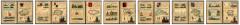
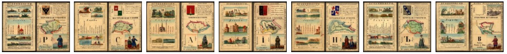
This dataset is sourced from an elegant deck of playing cards created in 1856 to teach members of Russia's elite families about the empire they inhabited. The cards—all 80 of them—provide us with a unique perspective on how the subjects of the tsar “saw” their country on the eve of the emancipation of the serfs.The Format
9 cvs files (tabular data), 5 shapefiles (vector data), readme, table of contents, codebook, glossaryContent
The dataset contains hundreds of attributes describing the distribution of economic activities, ethnic groups, geographical features, and historical "particularities." If you have ever wondered where tobacco was grown or which provinces were home to volcanos, this is the dataset for you!The shapefiles include high-quality custom historical boundary data for provinces and autonomous regions, as well as location data for all provincial and district towns.