The Imperiia ProjectMain MenuResearch Dashboardsmaps, visualizations, and moreVeles: The Data CatalogOngoing ProjectsThe MapMaker PodcastEvery story starts somewhere.Teach with MapsGalleriesKelly O'Neilldc20b45f1d74122ba0d654d19961d826c5a557f5The Imperiia Project // Davis Center for Russian and Eurasian Studies, Harvard University
Vaza Province
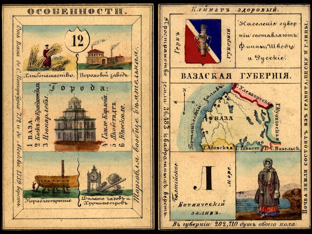
12020-08-16T23:36:39-04:00Kelly O'Neilldc20b45f1d74122ba0d654d19961d826c5a557f592Item in the set of geographic playing cards produced in Russia in 1856. These were elaborately illustrated, beautifully-produced playing cards laden with pedagogical and ideological value. There is one card for each province of the Russian Empire.plain2020-08-16T23:37:18-04:001856Kelly O'Neilldc20b45f1d74122ba0d654d19961d826c5a557f5
This page has paths:
12020-08-17T02:40:05-04:00Kelly O'Neilldc20b45f1d74122ba0d654d19961d826c5a557f5The Playing Cards: patience solutionKelly O'Neill5structured_gallery2021-02-09T11:53:53-05:00Kelly O'Neilldc20b45f1d74122ba0d654d19961d826c5a557f5
12020-08-17T10:57:35-04:00Vaza Province5geographic playing cardplain2020-09-15T00:28:27-04:0063.096, 21.61577(Vazaskaia guberniia)
Provincial town: Vaza Area (sq miles): 16,053 Population: 202,710 Population density: 12.6 people per square mile Towns: 6 Trade note: Trade is generally active. Climate note: healthful