The Imperiia Project: a spatial history of the Russian EmpireMain MenuProjectsDashboardsData CatalogMapStoriesGalleriesGamesWho said history was boring?Teach Our ContentCiting the ProjectKelly O'Neilldc20b45f1d74122ba0d654d19961d826c5a557f5The Imperiia Project // Davis Center for Russian and Eurasian Studies, Harvard University
Maxima
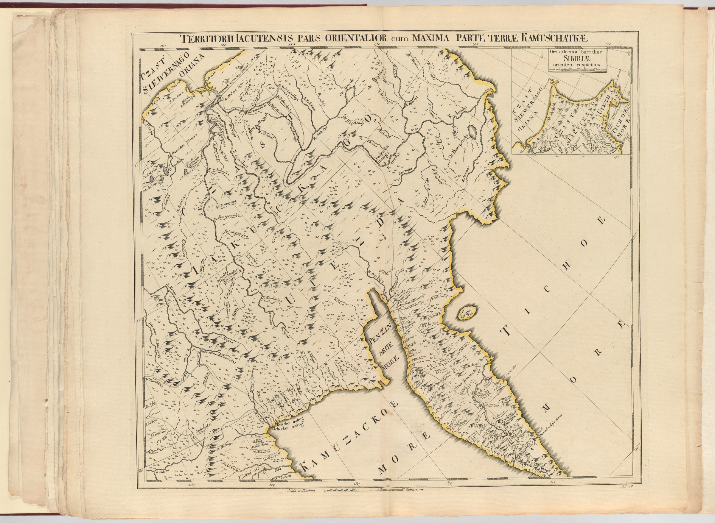
12020-04-29T22:20:50-04:00Kelly O'Neilldc20b45f1d74122ba0d654d19961d826c5a557f594Full Title: Territorii Iacutensis pars Orientalior cum Maxima Parte Terre Kamtschtkae // by Joseph DeLisle (St. Petersburg, 1745) // Harvard Map Collection. Permanent catalog link: http://id.lib.harvard.edu/alma/990038945480203941/catalogplain2020-04-30T16:06:42-04:001745Kelly O'Neilldc20b45f1d74122ba0d654d19961d826c5a557f5
This page has tags:
12020-04-29T22:21:10-04:00Kelly O'Neilldc20b45f1d74122ba0d654d19961d826c5a557f5Pairing 1 (Round of Sixteen)Kelly O'Neill11plain2020-05-05T13:54:32-04:00Kelly O'Neilldc20b45f1d74122ba0d654d19961d826c5a557f5
This page is referenced by:
12020-04-30T15:41:43-04:00Maxima8A map with pretensions, this is a sheet from the "Atlas of Russia" - the first "modern" atlas of the Russian Empire published by the Imperial Academy of Sciences. The man at the helm of the atlas project was a French cartographer, Joseph Nicolas de L'isle.plain2020-05-05T13:51:01-04:001745A map with pretensions, this is a sheet from the Atlas Rossicus - the first "modern" atlas of the Russian Empire published by the Imperial Academy of Sciences. The man at the helm of the atlas project was a French cartographer, Joseph Nicolas de L'isle (whose name often appears as Delisle). The map shows Kamchatka as part of Yakutia (Iakutia), with the Kamchatka Sea (Kamczackoe More) separating the peninsula from the important settlement at Okhotsk to the west.
One of the most interesting features of the map is the depiction of the overland travel routes linking inland Siberia to the coasts of the Arctic and Pacific.