Imperiia: a spatial history of the Russian EmpireMain MenuAboutProjectsDashboardsData CatalogMapStoriesGalleriesGamesWho said history was boring?Teach Our ContentCiting the ProjectKelly O'Neilldc20b45f1d74122ba0d654d19961d826c5a557f5The Imperiia Project // Davis Center for Russian and Eurasian Studies, Harvard University
1Sevastopol_detail_courtesy_Algernon_Percy.jpgSevastopol_detail_courtesy_Algernon_Percy.jpg2018-03-07T11:41:49-05:00Image 1: The City Enlightened1plain2018-03-23T03:52:49-04:00
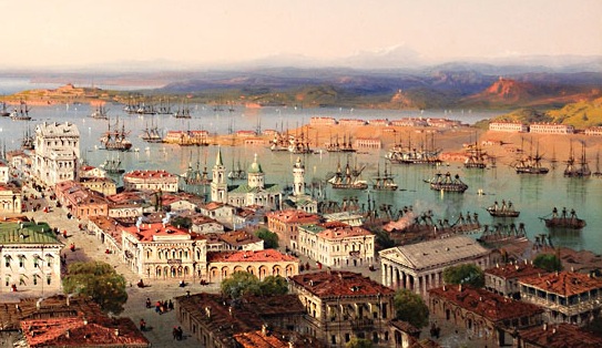
This image shows Sevastopol's neoclassical architecture. Note the domed building in the middle of the scene, this is the admiralty building of the Black Sea Fleet. Also featured is the naval officer's club and library, designed to resemble the Parthenon, in the lower right.[1] The port appears quite busy. The city, constructed largely of granite, has a white appearance. There seems to be hardly any distinction between sea and land, as the city runs right up to the water's edge. It is as though the buildings themselves sprang up from the sea - a fitting notion, given that the creation and building up of the city is due to its geographic positioning on a strategically important body of water.
Image: “Cornucopia Magazine Crimea: The West Coast.” Accessed March 20, 2018. http://www.cornucopia.net/magazine/articles/crimea-the-west-coast/
[1] McCormick, Richard C. A Visit to the Camp before Sevastopol. 212 p. New York: D. Appleton and company, 1855. //catalog.hathitrust.org/Record/001602521.