Vol. 1: History through Playing Cards
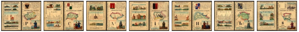
The Source: This dataset is sourced from an elegant deck of playing cards created in 1856 to teach members of Russia's elite families about the empire they inhabited. The cards—all 80 of them—provide us with a unique perspective on how the subjects of the tsar “saw” their country on the eve of the emancipation of the serfs.
Data format: 9 cvs files (tabular data), 5 shapefiles (vector data), readme, table of contents, codebook, glossary
Content: Hundreds of attributes describing the distribution of economic activities, ethnic groups, geographical features, and historical "particularities."
Geospatial coverage: empire-wide
Spatial Units: 3 semi-autonomous regions (polygons); 77 provinces (polygons); 417 towns (points); 180 rivers (lines)
Temporal coverage: early 1850s